


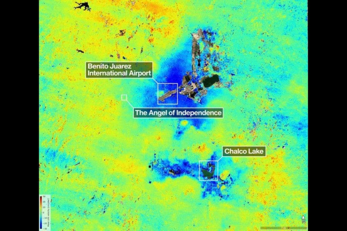
The joint India-US NASA-ISRO Synthetic Aperture Radar (NISAR) satellite mission has reportedly detected alarming levels of land subsidence beneath Mexico City, highlighting how parts of the densely populated capital are sinking at a rapid pace due to excessive groundwater extraction and urban pressure.
Scientists associated with the NISAR mission said advanced radar imaging technology revealed detailed patterns of ground deformation across the city, with some areas showing significant sinking over relatively short periods. Researchers believe the data could help governments better understand urban environmental risks and plan long-term mitigation strategies.
Mexico City has long faced subsidence problems because much of the metropolis is built on the soft sediment of an ancient lakebed. Rapid urbanization and continuous groundwater pumping have accelerated the sinking process, damaging buildings, roads, pipelines, and public infrastructure.
The NISAR satellite, developed jointly by Indian Space Research Organisation and National Aeronautics and Space Administration, uses sophisticated synthetic aperture radar technology capable of detecting minute changes in Earth’s surface with extremely high precision.
Experts say the mission represents one of the most advanced Earth observation collaborations between India and the United States, designed to monitor natural hazards, climate impacts, ecosystem changes, glacier movement, earthquakes, and land deformation across the globe.
According to researchers, satellite-based monitoring provides a much clearer picture of how urban centers are changing over time and can help authorities identify high-risk zones vulnerable to structural instability and flooding.
Environmental analysts noted that land subsidence is becoming an increasingly serious global issue affecting several major cities due to over-extraction of groundwater, rising population pressure, and climate-related stress on water resources.
In Mexico City, some regions have reportedly sunk by several meters over the past decades, creating long-term challenges for urban planning and disaster management. Scientists warn that continued subsidence could worsen drainage problems, increase flood risk, and strain aging infrastructure systems.
The NISAR mission is expected to play a major role in future climate and environmental monitoring by providing frequent and highly detailed radar observations of Earth’s changing surface conditions.
Indian space scientists have described the mission as a major milestone in international scientific cooperation and a significant achievement for India’s growing space technology capabilities.
Experts believe the data generated by NISAR could also prove valuable for monitoring environmental risks in Indian cities facing similar issues related to groundwater depletion, urban expansion, and land instability.
The findings regarding Mexico City have once again drawn global attention to the environmental consequences of unsustainable urban growth and the increasing role of satellite technology in identifying and addressing complex climate and infrastructure challenges.